A status yellow wind warning has come into effect for the entire country and will remain until 6pm.
Met Éireann has also issued a status yellow rainfall warning for Connacht, Leinster, Cavan, Monaghan and Donegal.
It came into effect at 9am and will remain in place until 6am tomorrow morning.
A status orange wind warning will take effect in Galway, Mayo, Clare, Kerry and Limerick at 6pm this evening and will run until 3am on tomorrow.
..Storm Lorenzo will move closer to the northwest coast this evening. As a result, southwest winds will increase to gale force along west & southwest coasts, generating potentially damaging gusts there. Heavy rain will move into Connacht & west Ulster also#stormlorenzo #Lorenzo pic.twitter.com/TXjWLgcJfU
— Met Éireann (@MetEireann) October 3, 2019
Met Éireann’s head of forecasting Evelyn Cusack has advised the public to be prepared for some wet and windy weather, with a risk of some fallen trees and coastal flooding and perhaps some damage along the west coast.
“We still have orange warnings for five counties – we have taken Cork out of the orange for the wind.
“The storm is approaching, the pressure is falling rapidly. It looks as if it won’t be as bad as it could be given its tropical origin.
“But we still expect significant winds on the west coast with a risk of some coastal flooding and damage, very high waves coinciding with low pressure and also high tides,” she told RTÉ radio’s Morning Ireland.
“That’s from Mayo to North Kerry. Further inland winds won’t be as strong.
“There will be gusting later this morning from 90-100 kms per hour, from a south easterly direction.
“Later on as the storm centre moves in from the north west, the winds veering round to a westerly direction then picking up again in more western areas.
As the ground is saturated, the ground is very wet so the trees are in full leaf, and that’s why we’re giving more impacts from this level of winds than if the storm were happening in January.
“There is certainly a high risk of trees down.”
Ms Cusack added that it now looks like there won’t be too much rain in Munster, “so we’ve taken Munster out of the yellow rainfall warning, but for the rest of the country there will be some spells of heavy rain, moving across the country from this morning.
“Between now and 6am tomorrow morning there is a risk of some localised flooding. The rain will be more sporadic.”
She added that for the east coast the south easterly gale this afternoon could produce a little overtopping.
Storm Lorenzo “is a different beast from Ophelia,” she said.
“Of course every storm is different, both were hurricanes.
“Lorenzo lost its hurricane status 1,000kms from the south west of Ireland yesterday afternoon, while Ophelia remained a hurricane very close to Ireland, within 500kms.”
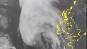
Latest infrared satellite imagehttps://t.co/I9iUsvqWtN#lorenzo #stormlorenzo pic.twitter.com/WsT4T7ScSN
— Met Éireann (@MetEireann) October 3, 2019
Local Government Minister Eoghan Murphy has warned that Lorenzo will not be “one homogenous weather event” and that the public needs to pay attention to local conditions and act accordingly.
“This is a national event in terms of being a wind and rain status yellow, and six counties on the west coast are under a status orange,” he said.
“This is where our primary concern is in terms of wave surges and coastal flooding. But the wind and rain across the country will have unpredictable impacts in terms of flooding being likely, power outages being likely, and also thunderstorms.
“In terms of public safety in coastal areas and exposed piers and the orange areas, we’re asking people to stay back, stay high, and stay dry and to avoid coastal roads during the orange period.
“There may be power outages in parts of the country. So we’re asking people to check with their neighbours and the elderly if they can, to make sure that they have things like batteries in their torches, phone chargers in their cars, and their Eircode to hand as well in case of an emergency,” he said.