
The entirety of County Waterford is subject to a Status Orange Rain Warning from Met Éireann.
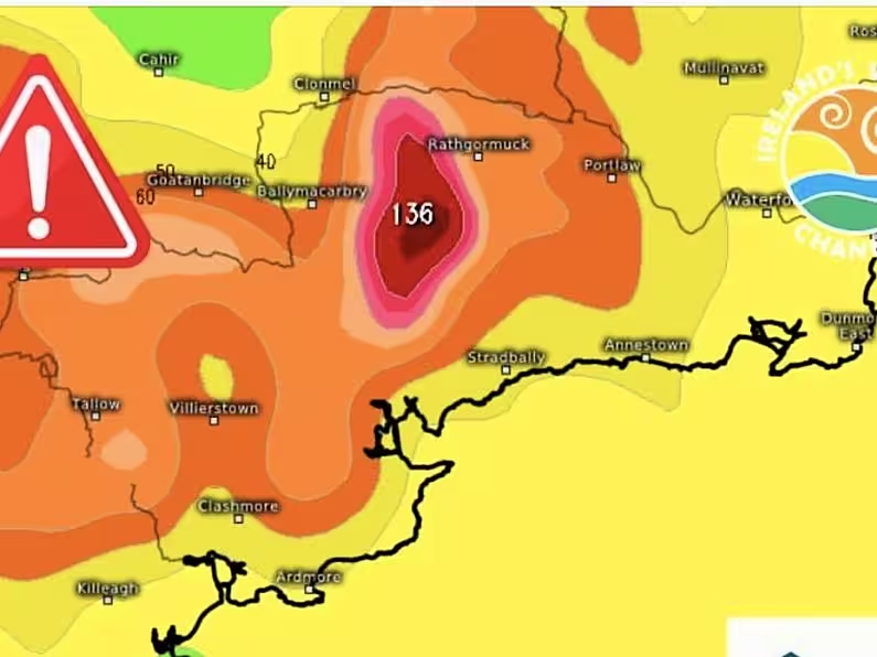
Cathal Nolan from Ireland’s Weather Channel says the latest models show up to 110mm of rain could fall in parts of West Waterford. The average monthly rainfall for September normally stands at 85mm.
Nolan says some parts of Waterford should realistically be under a red warning today.
High tides in Waterford come into effect at the following times today:
Dungarvan, Youghal & Ardmore: 4.35pm.
Tramore: 4.40pm.
Cheekpoint: 5.05pm.
Waterford: 5.20pm.
Surface water levels will be elevated in Waterford on Sunday due to high accumulations of rainfall over a 6 to 12-hour period. Impacts are likely to include localised flooding from urban and fast responding smaller watercourses/catchments, drains, channels and flooding from overland flow.
Waterford City and County Council’s severe weather management team met on Saturday morning and they are currently monitoring the situation. Ground crews are on stand-by to deal with any issues that may arise, such as localised flooding, blocked drains, gulley overflows, etc.
Waterford City and County Council advises the public to exercise caution, heed public safety advice and avoid unnecessary journeys as driving conditions may be hazardous, with surface water flooding expected.
Motorists are advised to avoid driving through flowing or standing water and are reminded to be conscious of vulnerable road users such as pedestrians and cyclists.
Members of the public can contact Waterford City and County Council’s Customer Services Desk on 0818 10 20 20 and calls will be transferred to the Council’s emergency services number.
Please note the following emergency contact numbers below:
Emergency 999/112
Uisce Éireann 1800 278 278
ESB Networks 1800 372 999
Gas Networks Ireland 1800 205 050
For the latest Waterford News and Sport, tune into WLR News on the hour and download the WLR App for news on demand.